A
Historical Journey
of "Bubblin' Crude"
North Burnaby --
Traditional
Cache
N49 15.586 W122
58.347

  Oil
that is. Black Gold. Texas Tea. Oil
that is. Black Gold. Texas Tea.
As the Fraser
River gold
ran dry and the last of the giant trees were chopped down, speculators
searched Burnaby for other natural resources that could prove
lucrative.
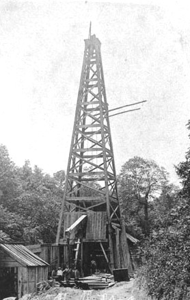
In 1918, the dream appeared to become reality when small traces of oil
were discovered along Crab Apple Creek.
The newly
tapped Alberta
oil fields were turning paupers into millionaires every day. Oil
was recently discovered around the tar pits of Los Angeles. And
with
the popularity of the automobile and other oil guzzling machines, the
production
of oil would make Burnaby one of the most prosperous municipalities in
Canada. The public and the local government were more than
willing
to buy into the dream.
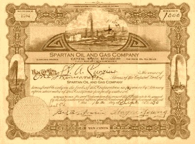
| With
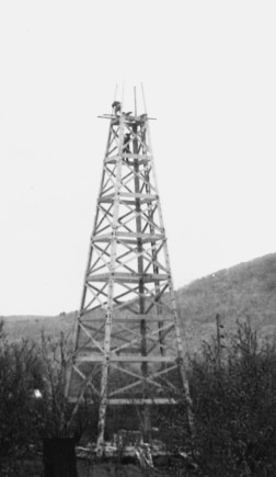
revenue made by selling shares, the Spartan Oil Company constructed two
rigs in 1922. The first well was built on the north side of Still
Creek and the second along Broadway. Drilling immediately
commenced.
The
truth of the matter is that everyone jumped the gun. With such a
rush to strike it rich few people took note that the initial oil
samples
were scant at best. As it turned out, what little oil that was
beneath
the surface cost more to extract than what it was worth. By the
end
of the decade, the stocks were worthless.
The
two oil rigs were a prominent landmark for a good part of 20 years
before
they were finally dismantled.
|
 |
This
particular area of
Burnaby is historically significant for another reason, however.
Seventy years before the oil rigs were built, this was virgin
land.
Few Europeans had set foot beyond the Fraser delta. The first
inland
expedition between the Fraser River to Burrard Inlet took place, in
part,
along this stretch of Still Creek. Documentation of this
journey
along with the discovery of Still Creek is outlined in the letter below.
Royal
Marine Camp, Queenborough, 25 April, 1859
To
His Excellency
Colonel
Moody
Commanding
Royal
Engineers
Sir,
I
have the honour to inform you that according to your order, I proceeded
last Monday in charge of an exploration expedition consisting of
Captain
Bazalgette, RM, one Private, RM, and three Indians with rations for
five
days for the purpose of ascertaining the relative position of Burrard
Inlet
with regard to Queenborough.
The
route I pursued for the purpose of affecting this was by the small
River
Brunette to Burnaby Lake, making the latter my Head Quarters.
The
distance from Queenborough to the lake I ascertained to be by the River
about 6 miles. The river is exceedingly tortuous in its course, and its
stage at the time that I proceeded up it was very low, but perfectly
navigable
for small canoes the portages owing to the fallen timber are numerous;
but these obstacles might easily be removed.
The
Lake is two miles and a half in length by one in breadth and the
deepest
part that I could find, I sounded at two fathoms, its entire shores are
also very swampy – its bearing is N.70 W. from where the Brunette
running
to the Fraser flows out of it – and is about N.70 W. of Queenborough.
On
the Second day I despatched Captain Bazalgette R.M., to reconnoiter the
head of the lake and he discovered a river which he followed up on a
Westerly
course for 3 miles (Still Creek).
This
river runs into a lake but with an almost imperceptible motion, it is
also
much deeper than any other part of the latter that I sounded. Its
average
depth being three fathoms, it also winds in small turns of every fifty
of sixty yards but its general bearing is West, its shores are swampy
and
covered with alder, its general appearance might be likened to a
Canal.
On
the same day I started with an Indian and two days provisions and took
a course due North from the eastern point of the lake over a Mountain
600
feet above the level of the sea – covered with dense forest – on
reaching
the summit I found Burrards Inlet to be immediately beneath it on the
opposite
side branching off into two arms the Southern most one of which bore to
the eastward and appeared to terminate within a short distance. The
Northern
most one hugging the base of the opposite high range of mountains was
shut
out from any observation. The mountain I ascended had an exceedingly
steep
descent to the Northward the breadth of the inlet was at the broadest
part
two miles: observing on this occasion that the mountain a short
distance
from where I had crossed it terminated abruptly to the Eastward and
that
a comparatively cleared valley about a mile in width skirted it in the
direction of the Inlet, I devoted my third day to endeavouring to find
out the nearest and most direct point from the latter to Queenborough
and
by returning about a mile and a quarter down the river Brunette from
the
Lake, I entered the valley and found it lead over a perfectly level and
nearly cleared Country direct to the termination of the Southernmost
branch
of the inlet the distance from River to the latter being about two and
a half miles and I compute the distance that exists between that part
of
the river and Queenborough to be about three miles in a direct line
this
would make the nearest point of the Inlet five and a half miles from
Queenborough.
On
the fourth day I tried to get up the River at the head of the Lake
further
than Captain Bazalgette had been but after three miles the snags were
so
numerous from the fallen trees that I found the labour of getting the
Canoe
over Too great to proceed much further than he had already been the
depth
of the River continued the same at this point – it also flows through a
perfectly unbroken valley which heads due West to Burrard Inlet. From
the
head of the lake and the distance across the former I should say
to be about eight miles.
I
have the Honour to be
Sir,
Your
Most Obedient Servant
G.S.
Blake
Lt.
, R.M.A..
|
 It
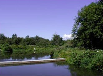
is a blessing in disguise that the oil wells never became lucrative,
for
this area of Burnaby is very much like it was when G.S. Blake first set
eyes on it over a century ago. Despite a large industrial
presence
upstream, the wildlife is flourishing along the shores of Still
Creek.
Expect to see trout, rodents, coyotes, grasshoppers, beavers and frogs
during your journey. It
is a blessing in disguise that the oil wells never became lucrative,
for
this area of Burnaby is very much like it was when G.S. Blake first set
eyes on it over a century ago. Despite a large industrial
presence
upstream, the wildlife is flourishing along the shores of Still
Creek.
Expect to see trout, rodents, coyotes, grasshoppers, beavers and frogs
during your journey.
The cache is
situated
Southwest of where the oil well once stood. Because of the swampy
conditions, it would be virtually impossible to place a cache exactly
on
the site.
THE CACHE
 Keep
in mind that when you visit this cache you're walking in the footsteps
of the brave men and women that explored this country. The
journey
is designed to emulate the the trials and tribulations the early
pioneers
faced. This will not be a park and grab cache. You are the
explorer. Keep
in mind that when you visit this cache you're walking in the footsteps
of the brave men and women that explored this country. The
journey
is designed to emulate the the trials and tribulations the early
pioneers
faced. This will not be a park and grab cache. You are the
explorer.
Where can you
park?
I'm not telling ya. Where's the trail head? I'm not telling
ya. OK, I'll give you a hint. The trail head is beside a
pedestrian
bridge.
The trail is
cleared once
a year by the parks service in order to gain access to drain
channels.
Brave explorers and teenagers usually keep the path more or less open
throughout
the remainder of the year. However, the foliage is very resilient
and the trail can be clear one week and seemingly impassible the
next.
In the summertime, the grass grows to the height of six feet causing
short
people and children to disappear without warning. Watch your
step.
The trail is uneven and passes numerous beaver slips, drainage channels
and creeks -- some of which are hidden under years of decaying
flora.
For this reason I don't recommend this area for night caching.
Plan
on getting your feet wet. On rainy days, plan on getting
drenched.
Clumsy people should expect to fall into the water at least once.
Stinging nettles and brambles are in abundance. The water table
rises
and falls causing swamp-like conditions throughout the area. To
avoid
getting sucked into a mud pit, it is best to keep to the path as it is
located on the highest ground. This is one area bushwhacking a
shortcut
will do you no good.
Now don't let
those warnings
put you off. It's truly a beautiful area worthy of a visit.
The cache is
more or less
out in the open and should be easy to find. Please try your best
to rehide the cache as you found it. You may have to act quickly,
however. A Beaver has set his sights on the cache and may beat
you
to it.
Enjoy your
visit and remember...
...every
Geocacher is
a potential explorer. Within his or her own breast burns the same
fire that urged adventurers of old to set forth in their sailing ships
to distant lands.
|


 It
is a blessing in disguise that the oil wells never became lucrative,
for
this area of Burnaby is very much like it was when G.S. Blake first set
eyes on it over a century ago. Despite a large industrial
presence
upstream, the wildlife is flourishing along the shores of Still
Creek.
Expect to see trout, rodents, coyotes, grasshoppers, beavers and frogs
during your journey.
  Keep
in mind that when you visit this cache you're walking in the footsteps
of the brave men and women that explored this country. The
journey
is designed to emulate the the trials and tribulations the early
pioneers
faced. This will not be a park and grab cache. You are the
explorer.