VIRTUAL / OTHER CACHES

This section will be a compilation of historic places unsuitable for a cache.  Way points and photographs will be added to this page as they become available.

CASCADES DRIVE IN THEATRE (1946 - 1980)
N49 XX.XXX W122 XX.XXX

The Cascades Drive-In was the first outdoor movie theatre in Canada.  On opening night, August 30 1946, cars began streaming into the spacious grounds for a showing of "Home in Indiana" two hours before the movie was scheduled to start.  By eight PM the place was nearly packed to the 800-car limit.  Hamburgers, hot dogs, pop corn, coffee and Cascades Drive In Signcigarettes were served directly to cars by uniformed car hops.  Heating baby bottles was an extra service.

Its instant success ushered in an era of Drive-In theatres and fast food restaurants along Granview Highway (now Canada Way) and the Lougheed Highway.  But by the mid 1970s the novelty began to wear thin and by 1981 all but a few drive-in theatres were closed down.

Other defunct outdoor theatres:

Lougheed Drive In (1949-1981): Lougheed & Madison -- Now a Business Complex.
The Drive In (1949-197?):  Lougheed & Holdom --  Now a car dealership.
Paramount Drive in: (1950-1059): N49 15.507 W122 57.818  Lougheed & Sperling -- beside Dairyland)  Now part of Dairyland's parking lot and a skytrain station.
 

TRAIN WRECKS

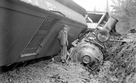
There were two major train derailments in Burnaby around the turn of the 20th Century.  Both wrecks were attributed to soft soils.

Brunette River Train Wreck: N49 XX.XXX W122 XX.XXX

On November 28th 1909 22 Japanese labourers were killed when a land slide caused a train to derail.  It is still considered the worst rail disaster in Burnaby's history

Legend of the Sinking Train -- N49 15.720 W122 58.955

The Great Northern Railway was constructed through Burnaby from New Westminster after the Fraser River Railway bridge was completed in 1904.  Although the route chosen along the north shore of Burnaby Lake offered good level grades, the peat bog at the western end of the lake and along Still Creek demanded the construction of a costly roadbed.

A dangerous sinkhole appeared between Sperling Avenue and Douglas Road and the roadbed suddenly sank 15 feet, leaving train tracks underwater and forcing the railway to cancel passenger and freight service.  A large work force then poured an average of 30 carloads of sand and gravel into the sinkhole daily. 

Nap Peltier, who claims to have been one of the members of this work crew, was interviewed by historian Bill Hastings in 1959.  To date, no documents have been found to confirm his story:

"We used to take a gravel train out on the track to the end and dump the gravel and go back for another load...  One day we got to the work site close to noon so we did not dump the gravel and went to lunch.  When we got back the train was not there.  All we saw were the tracks going down into the muddy water with bubbles coming up...  ...the whole thing sank out of sight.

There was a lot of trouble, but nobody did much about it except to spend a great deal of time fishing for it.  We never did connect with it and eventually gave up.  It must still be there."
 

THE CREST (built 1954)
N49 13.937 W122 54.393

This neighbourhood was one of the first planned residential developments to break from the traditional street grid pattern.  We owe today's driving nightmare of cul-de-sacs and dead end roads to this experiment.  Located around a central loop road with only one access point, the homes built along Crest Drive showcased the latest modern conveniences available to would-be home owners in 1954.  Architectural styles in this well preserved neighbourhood range from California Modern to the basic bungalow.  Picture windows, a new technological breakthrough at the time spawned from the modern skyscraper, are very prominent.  Many of the homes in this "Street of Dreams" were considered quite luxurious in their day.


In the perfect suburban society of 1954, The Crest street pattern was to be placed side by side along major thoroughfares.


The homes, primarily accessed through back lanes, made the central loop road traffic free.  This allowed a safe haven for children as the central block could be used for a school or a small park depending on the need.   In the case of The Crest, the central block was used for additional housing.


The idea never caught on.  Part of the reason behind this may be the fact that it was a suburban lifestyle based on the automobile.  Commercial property was never considered in the overall plan.  The Crest is the only block that was ever built.

TALLEST RECORDED TREE IN BURNABY (cut down 1903)
N49 16.590 W122 58.223


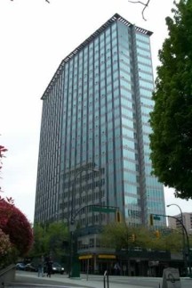
A 280 foot tree was logged by L.T. Dundas in 1903.  To put it in perspective, the tree was taller than the New Downtown Library complex and just 10 feet shorter than The Electra (B.C. Hydro Building) on Burrard Street.  The stumpage from that tree and surrounding trees can still be seen in and around the Kensington Pitch and Putt park.

GIANT GRANITE BOULDER
N49 16.649 W122 56.649

During the last ice age, large chunks of the coast mountain chain were sheered off by the force of a giant glacier as it slowly moved across the landscape.   But when the glacier finally receded 100,000 years ago, it dropped the debris helter skelter across what is now Burnaby in the form of giant  granite boulders.  Early settlers quickly found that these huge rocks were perfect for masonry and they were searched out for use as house foundations and fencing.  A few of the boulders still exist, however.  Most are tucked within the forest of Burnaby mountain but the largest accessible remnant of the ice age sits at the entrance of Squint Lake Park. 

HERITAGE HOMES

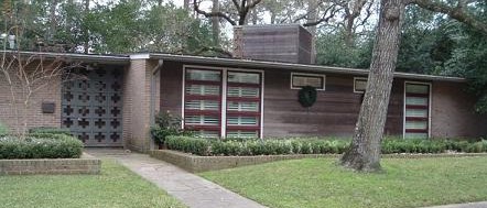
Many structures were saved from demolition and shipped to Burnaby Village.  The list below gives the original co-ordinates of the houses that are now inside the museum.

Jesse Love Farm House -- N49 13.821 W122 54.959 
--  the co-ordinates are for the Oak tree which the Love family planted by their homestead.  The Oak tree is right on the side of Cumberland Road ripping up the sidewalk as it grows.

Irvine House -- N49 XX.XXX W122 XX.XXX 
-- now part of a soccer field behind 8 Rinks.

Seaforth School -- N49 15.902 W122 58.955 (There is now another school on the site)

William Holmes Homestead (1860) N49 XX.XXX W122 XX.XXX
-- originally torn down for the Burnaby Lake trolley Line.  Now single family homes.
 

OTHER HOMES

William 
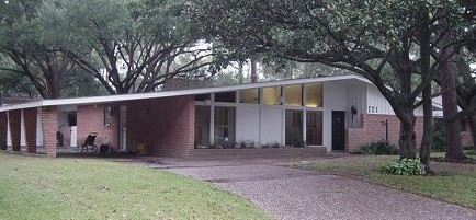
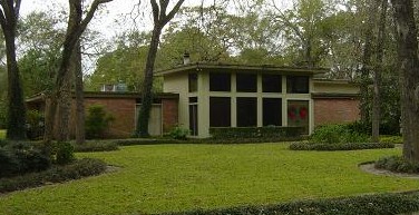
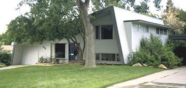
& Ruth Baldwin House (1965) -- N49 14.033 W122 54.396
-- Situated along the south shore of Deer Lake, this home was designed by famed local architect Arthur Erickson and it is considered to be the last Erickson home to be completely preserved.  Now owned by the City of Burnaby it is the first and only modern home to be listed in the historic registry. 


Home
The Big Blast
Crabtown Cache
Ghosts of Barnet
Secrets Submersed
Steam Heat
Gilley's Gully
The Yankees are Coming!
Other Caches
 Bubblin' Crude II
Tickets Please II
Five Cent War